“Atmospheric rivers form very differently from hurricanes, but the rainfall intensity can cause damage on the same scale. “There is potential for one of the longer-lived atmospheric river events that we’ve seen in the last 10 years or so,” said Marty Ralph, an expert on the phenomenon.”
-x-x-x-x-x-x-x-x-x-

By Matt Weiser and Tony Bizjak
mweiser@sacbee.com
Published: Wednesday, Nov. 28, 2012 – 12:00 am | Page 1A
Last Modified: Wednesday, Nov. 28, 2012 – 8:11 am
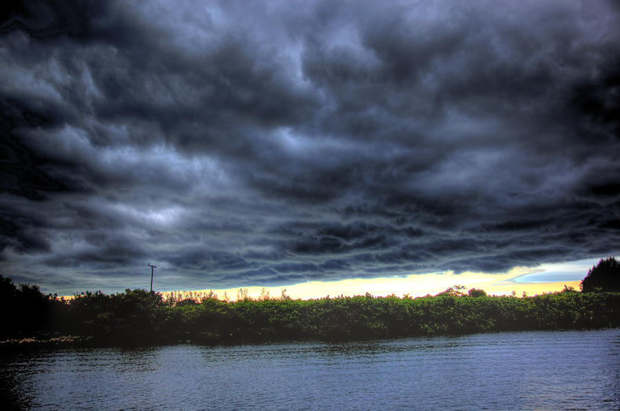
It’s shaping up as California’s equivalent of a hurricane: A series of warm, wet storms arriving today that will be unlike anything the state has seen in years.

By Sunday, weather experts say Sacramento could see 4 to 8 inches of rain, and the mountains of the Northern Sierra Nevada and Shasta regions could be deluged with 12 to 18 inches of rainfall.
If this comes to pass, Sacramento could receive more rain in a few days than it gets in an average January, typically the wettest month of the year.
The culprit is a weather phenomenon called an “atmospheric river,” which channels tropical moisture all the way across the Pacific Ocean like a fire hose. Sometimes called a “pineapple express,” these storms are viewed by weather experts as California’s equivalent of a hurricane.
Forecasters have “high confidence” in the timing and intensity of the storms. There is less certainty about where the fire hose will focus its wrath. Forecasts on Tuesday targeted Mount Shasta and the Northern Sierra, but that could change, said Rob Hartman, the hydrologist in charge of the California-Nevada River Forecast Center, a branch of the National Weather Service.

“It is kind of like when you turn your hose on in the front lawn without staking the end down. It kinda hops around a little bit,” Hartman said. “It could come a little bit further south. But there is a lot of moisture out there, and it’s coming our way.”
The first storm arrives today and lasts through Thursday. It is expected to be relatively mild.
The second hits Friday and will be the real soaker, lasting through Sunday with drenching rain and strong winds. A third, even wetter storm, may follow later on Sunday.
Sacramento could see sustained winds of 35 mph with gusts to 45 mph. The Sierra Nevada foothills could see gusts up to 55 mph.
These are warm storms and snow levels will be high – 7,000 feet and up. That means many Sierra highway passes could stay free of snow. But it also means more terrain will be exposed to rainfall runoff.
Atmospheric rivers form very differently from hurricanes, but the rainfall intensity can cause damage on the same scale.

“There is potential for one of the longer-lived atmospheric river events that we’ve seen in the last 10 years or so,” said Marty Ralph, an expert on the phenomenon at the National Oceanic and Atmospheric Administration’s Earth System Research Laboratory in Boulder, Colo.
“These are the types of events that are responsible for the biggest flood damages on the West Coast,” he said. “To me, that’s the analogue to the hurricane problem.”
Forecasters say the second storm will plant its bull’s-eye on Shasta, Tehama, Butte and Plumas counties, with lesser rainfall amounts farther south. This is worrisome, because these counties experienced large forest fires over the summer that now create a significant erosion and mudslide risk.
Of particular concern is the Battle Creek watershed in Shasta and Tehama counties, where the Ponderosa fire burned more than 27,000 acres in August.
Battle Creek is the focus of a $128 million salmon restoration project, still under way, funded by state and federal agencies. Heavy erosion in the watershed could damage habitat vital to the project’s success.
“We are very concerned about that,” said Lt. Mark Lillibridge, coordinator of the Shasta County Office of Emergency Services. “We’re going to get hammered, it looks like.”
Lillibridge said Shasta County will make sandbags available to residents. It also has swift-water rescue crews and a 300-member volunteer patrol on standby to assist in the storm.
In Sacramento, one of the capital region’s premier sporting events, the 30th annual California International Marathon, is expected to go ahead on Sunday despite the weather. Organizers say the race has never been canceled.
More than 15,000 people are expected at the 26.2-mile race, which starts at 7 a.m. Sunday near the base of Folsom Dam. It follows Fair Oaks Boulevard and finishes in front of the state Capitol in downtown Sacramento.
“Runners are hardy,” race spokesman John Schumacher said. “They’ll be ready.”
None of the Sacramento Valley’s major rivers is expected to see flooding problems.
The Sacramento River is predicted to spill into the Sutter Bypass on Saturday – a normal event in stormy weather. The Yolo Bypass downstream, between Sacramento and Davis, is not expected to flood.
On the other hand, many local creeks may experience flooding, and residents are advised to be ready.
Sacramento County officials urged people who live near creeks in flood-prone areas to have sandbags on hand in case creeks overflow their banks.
“If you live near a creek that has flooded in the past, I would always have sandbags on hand. It doesn’t take that many to protect a doorway,” county water resources spokeswoman Diane Margetts said.
Residents of unincorporated Sacramento County who experience neighborhood flooding can call the county at (916) 875-7246 for help.
Neighborhood flooding is also likely to become a significant problem because the region’s urban tree canopy is in the thick of leaf-fall season. This means streets and storm drains are at high risk of clogging.
Sacramento city and county officials urged people to clean leaves and other debris from around storm drains in their neighborhoods, and to monitor those drains during the unfolding storms.
“The biggest flooding problem this week is going to be plugged storm drains, especially with all the leaves,” said Margetts. “People don’t realize plugged storm drains are going to cause flooding. It can easily get into your garage or into your house.”
The city of Sacramento has assigned on-call crews to assist with downed trees, clogged drains and flooded streets. City residents can call 311 to have a crew dispatched to assist with street flooding.
High winds and soaked ground raise the potential for downed trees and power outages. Residents should be ready with flashlights, extra batteries, food and water, a battery-powered radio and an alternate means of charging cellphones.
They should also secure outdoor furniture and other objects to prevent them from becoming dangerous projectiles.
‘PINEAPPLE EXPRESS’ONLINE: • Check the forecast in your area www. wunderground.com/auto/ sacbee/CA/ Sacramento
• Post your weather photos online sacbee.com/ weatherphotos/
• Follow daily developments sacbee.com
© Copyright The Sacramento Bee. All rights reserved.
SOURCE:
http://www.sacbee.com/2012/11/28/5014591/river-of-storms-headed-for-northern.html#storylink=cpy